
The news is according to a document issued at a press conference held by the National Administration of Surveying, Mapping and Geoinformation. The program is part of the country’s efforts to safeguard its maritime rights and interests.
The first stage of the island surveying and mapping project was launched in 2009. China has already finished mapping islands located within 100 kilometers of its coastline. The second stage will cover islands including the Diaoyu Islands.
As of the end of 2012, China has identified and found the precise positioning of about 6,400 islands. It has also completed more than 4,900 island maps of three different scales.
.cntv.cn
15/1/13
Related posts:
Chinese ships seen in disputed waters for first time since LDP's win (Senkaku/Diaoyu issue)
Japan’s next PM: No quarter for China, reach out to Russia
Keen to make an impression: Japan-US military drills begin amid Asian island row
 |
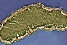
| China is to survey the Diaoyu Islands in the East China Sea as part of a program of mapping its territorial islands and reefs, it was revealed on Tuesday. |
 |
| China is to survey the Diaoyu Islands in the East China Sea as part of a program of mapping its territorial islands and reefs, it was revealed on Tuesday. |
 | |
| China is to survey the Diaoyu Islands in the East China Sea as part of a program of mapping its territorial islands and reefs, it was revealed on Tuesday. |
No comments:
Post a Comment